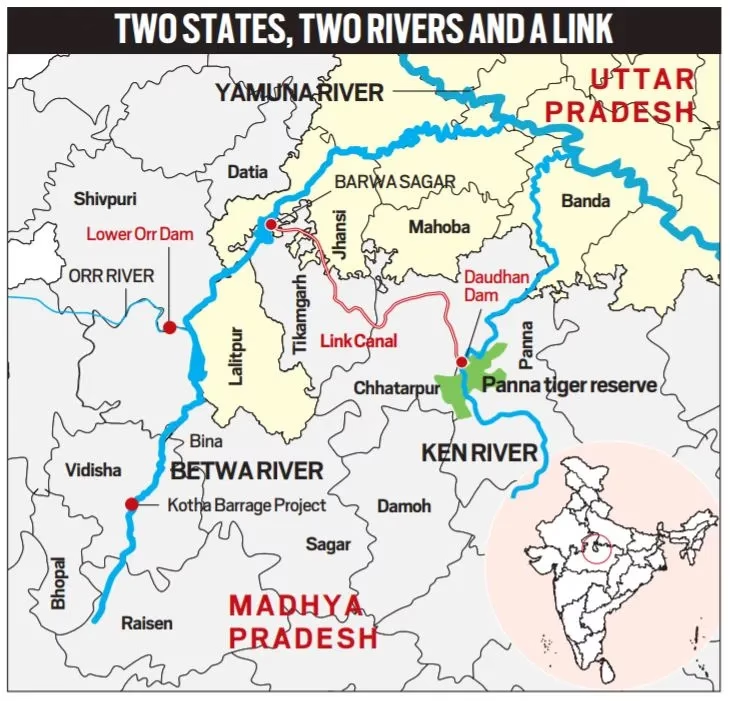
PM Modi laid the foundation stone for the inter-state Ken-Betwa river linking project in Khajuraho on 25th December. The KBLP envisages transferring water from the Ken river to the Betwa river, both tributaries of the Yamuna. The Ken-Betwa Link Canal will be 221 km in length, including a 2-km tunnel.
Why was this project needed, and what are the associated concerns?
Key Takeaways
According to the Jal Shakti Ministry, the project is expected to provide annual irrigation to 10.62 lakh hectares (8.11 lakh ha in MP and 2.51 lakh ha in UP) of land, supply drinking water to about 62 lakh people, and generate 103 MW of hydropower and 27 MW of solar power.
It is the first project under the National Perspective Plan for the interlinking of rivers, which was prepared in 1980. This plan has 16 projects under its peninsular component, including the KBLP. Apart from this, 14 links are proposed under the Himalayan rivers development plan.
Yamuna
Yamuna is a tributary of River Ganga. It has four main tributaries in the Himalayan region: Rishi Ganga, Hanuman Ganga, Tons, and Giri. In the plains, the main tributaries are Hindon, Chambal, Sind, Betwa and Ken. Tons is the largest tributary of Yamuna. Other small tributaries of the Yamuna River include the Uttangan, Sengar and the Rind.
The Ken-Betwa Link Project has two phases. Phase I will involve building the Daudhan Dam complex and its subsidiary units such as the Low-Level Tunnel, High-Level Tunnel, Ken-Betwa Link Canal, and powerhouses. Phase II will involve three components — Lower Orr Dam, Bina Complex Project, and Kotha Barrage.
The idea of linking the Ken with the Betwa got a major push in August 2005, when a tripartite memorandum of understanding for the preparation of a detailed project report (DPR) was signed among the Centre and the two states. In 2008, the Centre declared the KBLP a National Project. Later, it was included as part of the Prime Minister’s package for the development of the drought-prone Bundelkhand region. Eventually, on March 22, 2021, a memorandum of agreement was signed between the Ministry of Jal Shakti and the governments of Madhya Pradesh and Uttar Pradesh to implement the Ken-Betwa Link Project.
The project lies in Bundelkhand, which spreads across 13 districts of Uttar Pradesh and Madhya Pradesh. According to the Jal Shakti Ministry, the project will be of immense benefit to the water-starved region, especially the districts of Panna, Tikamgarh, Chhatarpur, Sagar, Damoh, Datia, Vidisha, Shivpuri and Raisen of Madhya Pradesh, and Banda, Mahoba, Jhansi and Lalitpur of Uttar Pradesh.

Environment and Social Impact
The river-linking project has faced intense scrutiny for its potential environmental and social impact. The project will involve large-scale deforestation inside the heart of the Panna National Park and Tiger Reserve.
One of the most controversial aspects of the project has been the submergence of around 98 sq km of Panna National Park, where tigers went locally extinct in 2009, and the felling of about two to three million trees. The Daudhan Dam is situated inside the national park.
Also, over the years, experts have sought that hydrological data of Ken’s surplus water be made public for a thorough review or fresh studies. A study published last year by IIT-Bombay scientists even found that moving large quantities of water as part of river-linking projects can affect land-atmosphere interplay and feedback and lead to a mean rainfall deficit of up to 12 per cent in September.
The dam will displace 5,228 families in Chhatarpur district and 1,400 families in Panna district due to submergence and project-related acquisition. The acquisition process has seen a lot of protests related to what locals have dubbed inadequate compensation and low benefits for the Panna district.

Modified Parbati-Kalisindh-Chambal-ERCP (Modified PKC-ERCP) Link Project
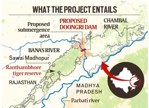
Rajasthan and Madhya Pradesh signed a Memorandum of Understanding (MoU) with the Union Ministry of Jal Shakti in January 2024 to implement the Modified Parbati-Kalisindh-Chambal-ERCP (Modified PKC-ERCP) Link Project. The project envisages integration of the long-pending PKC river link project with the Eastern Rajasthan Canal Project, under the national perspective plan of interlinking of rivers (ILR) programme of the Government of India.
The Eastern Rajasthan Canal Project (ERCP) is aimed at the intra-basin transfer of water within the Chambal basin, by utilising surplus monsoon water available in Kalisindh, Parvati, Mej and Chakan subbasins and diverting it into water deficit sub-basins of Banas, Gambhiri, Banganga and Parbati.
According to the Jal Shakti Ministry, the link project proposes to provide drinking and industrial water in 13 districts of eastern Rajasthan, and Malwa and Chambal regions of Madhya Pradesh, apart from providing irrigation in 2.8 lakh ha. area (or more) each in both the states (total of 5.6 lakh ha or more).
The Government of India formulated a National Perspective Plan (NPP) in 1980 for transferring water from water surplus basins to water deficit basins/areas. The National Water Development Agency (NWDA) has identified 30 links (16 under the Peninsular Component and 14 under the Himalayan Component) under the NPP.
Interlinking Projects under the National Perspective Plan
| Name | State benefitted |
| Mahanadi (Manibhadra) – Godavari (Dowlaiswaram) link | Andhra Pradesh and Odisha |
| Godavari (Polavaram) – Krishna (Vijayawada) link | Andhra Pradesh |
| Godavari (Inchampalli) – Krishna (Nagarjunasagar) link | Telangana |
| Krishna (Almatti) – Pennar link | Andhra Pradesh and Karnataka |
| Par-Tapi-Narmada link | Maharashtra and Gujarat |
| Bedti – Varda link | Karnataka |